


La Bastide Solage

placan
User
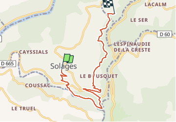

Length
7.4 km

Max alt
461 m

Uphill gradient
326 m
Km-Effort
11.5 km

Min alt
231 m

Downhill gradient
258 m
Boucle
No
Creation date :
2021-11-21 12:54:39.0
Updated on :
2021-11-21 17:05:15.717
4h08
Difficulty : Medium

FREE GPS app for hiking
 SityTrail
IGN / Geographical institutes
SityTrail Plus
The world is yours!
About
Trail Walking of 7.4 km to be discovered at Occitania, Aveyron, La Bastide-Solages. This trail is proposed by placan.
Description
Belle randonnée dans les châtaigniers
Positioning
Country:
France
Region :
Occitania
Department/Province :
Aveyron
Municipality :
La Bastide-Solages
Location:
Unknown
Start:(Dec)
Start:(UTM)
461727 ; 4865779 (31T) N.
Comments